 London
Green Belt Way
London
Green Belt Way
Accessibility to the London Green Belt Way
The Table and the "Usefull Links" below was updated 5 March 2023, but many links change - I'm wish people would stop moving things around.
The table shows accessibility to and near the route of the London Green Belt Way. It also gives information on many of the places the walk passes through.
The "Useful Links", below the table are to Councils and Organisations, with extra links to their relevant Accessibility Information.
If you know of any additions, or find a broken or corrupt link, please e-mail me details at seangbr@tiscali.co.uk.
Before using any of the information below read the Disclaimer on this website.
|
Stage |
Start & Finish points of each Stage with links to stage maps. |
Accessible Point or area referred to in information. |
Postcode with link to StreetMap + Grid Ref. |
Source & Hyperlink to accessibility information |
Notes |
|
1 |
TQ1561868480 |
Most of the grounds and some of the Palace are accessible to people with disabilities and the link has lots of information on this. |
|||
|
|
|
TQ1417169254
|
See map of walk - distance is 1.4 miles |
"National Trails and the Environment Agency have published 12 walks along different parts of the River Thames, all with level and wide paths, gentle slopes and rest areas" |
|
|
|
|
Thames Path, Walton Bridge |
TQ0929266468 |
Surrey County Council. - "Easy walks around Surrey" See details of "The Thames Path Walk from Walton Bridge" |
"A lovely walk upstream from Walton Bridge, along a level surfaced path towards the Shepperton Ferry. (Ferry not easily accessible)." |
|
|
Laleham Village outside All Saints Church north gate. |
Laleham Village postcodes
aren't great for directions. Use link below. TQ0514668916 |
Historic walk around
Laleham Village and River Thames - I love this. By Laleham Residents Association. |
Download walk at
LINK. If All Saints Church is open, then pay a visit, it's beautiful and has a few famous in the graveyard. |
|
|
|
|
Penton Hook Island, Penton Hook Lock - the link is for boats but is the best I can find. |
TQ0436969517 |
See map of walk - distance 0.7 miles |
"National Trails and the Environment Agency have published 12 walks along different parts of the River Thames, all with level and wide paths, gentle slopes and rest areas". |
|
|
|
Staines upon Thames |
|
|
Spelthorne Committee for Access Now (SCAN) has more information about accessibility in the borough. |
|
2 |
TQ0083872315 |
See map of walk - distance 0.3 miles |
"National Trails and the Environment Agency have published 12 walks along different parts of the River Thames, all with level and wide paths, gentle slopes and rest areas". |
||
|
|
|
Runnymede Tea Rooms & Memorials area. |
SU9963673144 |
Limited designated parking. Toilets by tea rooms. Partly accessible, slopes, some steps, grass paths. |
|
|
|
French Brothers Boat Trips, Runnymede Boathouse |
SL4 2SG SU9967473208 |
French Brothers Boat Trips | Accessibility to boat trips between Windsor and Hampton Court Palace. | |
|
|
|
Windsor Great Park |
TW20 0XU Bishopsgate SU9780272219 GU25 4QF Virginia Water car park SU9807368820 TW20 0UU Valley Gardens car park, off Wick Lane SU9777570582 |
Information covers the Savill Garden, The Valley Gardens, Virginia Water, The Long Walk and Deer Park car park. The first post code and grid ref. are of Bishopsgate where we enter Windsor Great Park. |
|
|
|
|
Windsor Town and Castle |
|
The Royal Borough website has a large section entitled "Travelling with a Disability". The website also has a section on "Things to Do", but please check-out what you want to do on the numerous things on offer here, or phone the relevant contact to get more information on how accessible they are. |
|
|
3 |
Windsor and Eton Bridge |
SL4 6AA SU9671177269 |
The Royal Borough of Windsor & Maidenhead | The Eton Walkway. A 2 mile circular walk connecting 18 points of interest around the town. Map and leaflet at link. Little accessible info. but most should be. | |
|
Maidenhead, Ray Mill Island |
SU9023782560 |
See map of walk - distance 0.3 miles |
"National Trails and the Environment Agency have published 12 walks along different parts of the River Thames, all with level and wide paths, gentle slopes and rest areas". |
||
|
|
|
Cookham Village Circular |
SL6 9QL (Nearest) SU8924385342 |
- see walk leaflet |
2.5 km easy walk around Cookham Village and along the River Thames. There is also a 7.5 km Large Circular Route and a 2.5 km Lock Route. |
|
|
|
Stanley Spencer Gallery, Cookham |
SU8971785335 |
"The Gallery has disabled access and a lift up to the first floor, so there is no problem for wheelchairs. There is parking on the High Street with a few disabled slots" |
|
|
4 |
Bourne End Station |
Bourne End and Spade Oak Lake SU8946787256 |
The Chilterns website has an "Walks, Rides and Countryside Activities" section - see "Access for All". Download Bourne End and Spade Oak Lake leaflet . |
||
|
Little Marlow Walks |
SU8944087632 Spade Oak Pub |
Two walks in the Little Marlow area. 3 miles and 6 miles. Please study the walks leaflet well and be aware of the bull (and cattle) in the riverside field just south of Spade Oak. There is also access to the walks from the small public car park just south of The Spade Oak pub. |
|||
|
|
|
West Wycombe Woodland Walk |
Chorley Road Car Park, West Wycombe SU8264994754 |
2.5 mile stile free walk. Download walk details. Please read carefully and check the walk is suitable to your needs |
|
|
|
|
West Wycombe Park, Village and Hill |
Postcode is entrance to West Wycombe Park SU8278195657 |
||
| 5 | West Wycombe to Old Amersham | Downley Common |
Parking at Commonside Postcode HP13 5YA & at Sunnybanks, Moor Lane, Downley HP13 5YP |
Downley Common and Hunts Hill Walk. | 2.8 mile stile free walk. Details of walk at Chilterns Area of Outstanding Beauty. |
|
|
|
Hughenden Manor |
HP14 4LA SU8609695395 For Hughenden Manor Church and Disraeli's grave there's also parking at the church. Grid Ref. SU8650495523 |
See "Hughenden Access Statement". |
|
|
|
|
Hughenden Manor
There is also parking and access to this walk at Downley Common |
HP14 4LA SU8609695395 For Hughenden Manor Church and Disraeli's grave there's also parking at the church. Grid Ref. SU8650495523 HP13 5YP SU8492895344 |
Chilterns Area of Outstanding Natural Beauty The Chilterns website has an "Walks, Rides and Countryside Activities" section - see "Access for All". |
The Chilterns Conservation Board, with the support of the Chilterns Society"has produced a booklet entitled "Miles without Stiles in the Chilterns - 20 easy access walks 1.5 to 4.5 miles". Walk 13 is Hughenden Manor and Downley Common (2.5 miles) and takes in part of the route of the London Green Belt Way. Please read the leaflet carefully before planning a trip. Note: Some of this route is quite rough underfoot and there is one long steep climb up through the woods to Hughenden Manor. |
|
Little Missenden |
Postcode is of St John the Baptist Church. SU9208998970 |
|
Little Missenden is a beautiful village with lots to see in a small area. It has a music festival every year in October (now 62 years) and is often used as a setting for TV and Movies including Midsomer Murders. Parking is easy in the centre of the village and the surfaces are flat with two good pubs to visit. Below is an easy access walk from Amersham to Little Missenden which can be done in reverse. |
||
|
|
|
Amersham, at the entrance to Shardeloes |
HP7 0RL SU9474897839
|
Chilterns Area of Outstanding Natural Beauty The Chilterns website has an "Walks, Rides and Countryside Activities" section - see "Access for All". |
Amersham to Little Missenden stile free walk. The walks leaflet (see walk 10) states "Access Information: Level walk. The walk is suitable for all terrain pushchairs as the path is easy to negotiate and there are only a few gates to open. This walk can be also done the opposite way from Little Missenden to Amersham. |
|
|
|
Amersham Museum |
SU9565697363 |
For access and visitor facilities see LINK. Also see the Amersham.org.uk website for much more information on the Old Town. |
|
|
6 |
Chenies Village Green |
Postcode is of St Michael's Church.
|
Chilterns Area of Outstanding Natural Beauty The Chilterns website has an "Walks, Rides and Countryside Activities" section - see "Access for All". |
The Chilterns Conservation Board, with the support of the Chilterns Society has produced a booklet entitled "Miles without Stiles in the Chilterns - 20 easy access walks 1.5 to 4.5 miles". Walk 8 is Chenies & Chess Valley Walk via Latimer (2.25 miles) and takes in part of the route of the London Green Belt Way. Please read the leaflet carefully before planning a trip. Note: Some of this route is quite rough underfoot and there are some climbs. |
|
|
|
|
Flaunden |
Postcode is the Green Dragon Pub TL0138500772 |
Flaunden on Wikipedia - a small entry, but it should grow. |
Scattered old village in the Chilterns - a village which moved location. Two pubs, the Green Dragon and the Bricklayers Arms. There are some level walks but no information yet. |
|
Chipperfield Common |
(postcode is the Two Brewers Inn) TL0436101634 |
Parks Herts has a 1.6 km Easy Access Walk through Chipperfield Common. |
|||
|
7 |
Kings Langley | Three Rivers District Council | The Council has a section on improving access to Walking and Cycling | ||
|
|
This is a general website with lots of information about access and a list of walks, etc in Hertfordshire. | Each link at the website has a different access point for that activity. |
Accessible Countryside / Hertfordshire This website does cover every county in England and Wales |
As well as walk there is information on parks, nature reserves and more. I apologise as some of the links are broken, but I thought this was a useful addition. | |
|
Verulamium Park, St Albans Also see AccessAble Guide. |
AL1 2DL (Postcode is Westminster Lodge Leisure Centre) TL1436206530 |
St Albans City & District Council See Walking & Cycling Section of above website |
More information about facilities is available at the EnjoyStAlbans website.
|
||
|
|
|
Cathedral and Abbey Church of St Alban |
TL1457307029 |
See the St Albans Cathedral website. |
Also see information on "access" at the the Cathedral.website |
|
|
|
Address of the start of the Samuel Ryder Trail TL1476609267 |
There is an "18 hole walk" around the city, entitled the Samuel Ryder Trail which takes in all the places associated with the founder of the Ryder Cup. Download leaflet. As this trails is mainly through the centre of the city, most if not all should be accessible. |
||
|
|
|
TL1357106892 |
See "Facilities and Access" section |
||
|
|
|
TL1362707312 |
See "Facilities and Access" section |
||
|
|
|
TL1362707312 |
See "Facilities and Access" section |
||
|
|
TL1362707312 |
Visit St Albans | Guided Walks around St Albans including, history, Fishpool Street, a Monastery Revealed and Ghosts and Ghouls.The Tours usually cost a small fee. | ||
|
8 |
For accessible points see the Alban Way Leaflet.
|
Note. Where our walk, London Green Belt Way, joins the Alban Way there is a steep set of steps up from the River Ver Path to the Alban Way. However, there are many other access points, so see the rest of the information on here. |
Please read all the details on the Alban Way leaflet before planning any walk. Also see a second leaflet from Smallford.org with lots more about the Alban Way..
Also see Wikipedia for more information.
Other websites: St Albans & District Council - report a fault on the Alban Way |
The Alban Way runs from between Cottonmill Lane and Westlers Bridge at Hatfield. It is 6.5 miles long. The leaflet states - "The Alban Way is a trail for cyclists and walkers along a former railway line. It is an important link in the local sustainable transport network and forms part of Route 61 of the Sustrans National Cycle Network. The Alban Way has a smooth surface, suitable for all users, with lighting at the Hatfield end. It has many access points, most of which are ramped or level. It provides a route for leisure, commuting and safe routes to school." Sustrans website states "Surface: Smooth and suitable for all users". IMPORTANT: This route does cross some roads, so please take care. |
|
|
|
Sopwell Nunnery Ruins |
Accessible from Cottonmill
Lane across flat grass. AL1 1HH OS Grid Ref. TL1496106401 |
Enjoy St Albans |
"Disabled Access: Sopwell
Nunnery is situated in a mainly level grassed area, but there is no path." Also see St Albans Museums. |
|
|
|
Mill Green Mill and Museum |
AL9 5PD TL2401109749 |
Welwyn Hatfield Borough Council also see Mill Green Mill and Museum website. |
Also see Council information on location. | |
|
|
|
Cole Green Lane, Welwyn Garden City Cole Green Picnic Area at Letty Green |
AL7 3DJ (nearest) SG14 2NL Postcode is Cowper Arms Public House |
See leaflet for details. Developed jointly by - |
Cole Green Way, from Cole Green Lane at Welwyn to Cole Green Picnic Area at Letty Green. This is a disused railway line which has been converted to a cycling / walking route with a level surface. It is accessible with a RADAR key at Cole Green Lane and Cole Green Picnic Area at Letty Green. There is parking at Letty Green. |
|
Cole Green Picnic Area at Letty Green
Hertford Town Football Club |
SG14 2NL (Postcode is Cowper Arms Public House) TL3200612051 |
See leaflet for details. Developed jointly by - |
Cole Green Way, from Cole Green Picnic Area at Letty Green to Hertford. This is a disused railway line which has been converted to a cycling / walking route with a level surface. It is accessible with a RADAR key at Cole Green Picnic Area at Letty Green and Hertford Town Football Club. There is parking at both Letty Green and Hertford Town FC. |
||
|
|
|
Hertford Town |
Postcode is the Council Building at Hertford Castle - please study links for access points TL3246912448 |
The Town Council website used to have a page with lots of useful information for Disabled People. However, I'm unable to find this at present. In the meantime you can see what is available by visiting their website. |
|
|
|
|
Hertford Museum |
TL3264012695 |
Disabled parking is available on Bull Plain. |
|
|
|
Hertford Heritage Trail |
Starts at
Hertford Castle SG14 1HR TL3246912448 |
Hertford Town Council | Hertford Heritage Trail is walk around the town visiting 41 historical sites. See leaflet. | |
|
9 |
Hertford & Ware Walks - Riverside Trail. 5.75 miles
|
Starts at Hartham Common.Car Park TL3278413082 |
Accessible Countryside / Hertfordshire - see leaflet for this walk
|
The walk is described as "Moderate (flat, some unsurfaced paths)". However, it does not give details about accessibility. Please get more information by using the contacts at the links before embarking on this walk. |
|
|
|
|
Ware |
Postcode is Amwell End |
See "Things to Do" section at Ware Town Council |
No known points of accessibility but see Ware Town Council for further information. |
|
|
|
Lee Valley Walks |
I have not added a start point as there are a lot of walks included. |
The Walks Section has lots of walks, some of which are suitable for disabled. |
See "Access Guide" to Lee Valley Regional Park. Also, see Lee Valley Walk at Wikipedia. |
|
|
|
Rye House Gatehouse |
TL3857409953
|
See section on Rye House Gatehouse.. |
|
|
10 |
Water-lily Wander around Bowyers Water - 2 miles. |
Pindar car park Windmill Lane, Cheshunt, Herts, EN8 9AJ. TL3683602350 |
See link to walk at Visit Lee Valley and download leaflet (link broken) - states "Particularly suitable for disabled people and pushchairs". |
||
|
|
|
Dobbs Weir |
TL3854608154 |
Good accessibility. "There is a toilet block with a cubical for people with disabilities, which can be found in the car park opposite the Fish and Eels Public House." |
|
|
|
|
Broxbourne Old Mill & Meadows |
(nearest postcode) TL3719606871 |
According to VisitLeeValley. "The site has car parking and toilet facilities both of which are suitable for disabled people." |
|
|
|
|
Royal Gunpowder Mills at Waltham Abbey |
TL3755601147 |
For accessibility see website. |
|
|
|
|
Epping Forest District Museum, Waltham Abbey |
TL3836200553 |
Good accessibility, see Visitor Information. |
|
|
|
|
Gunpowder Park, Sewardstone Road, Waltham Abbey |
TQ3859199333 |
Website states "All areas accessible to disabled visitors" |
|
|
|
|
Rammey Marsh |
EN3 6JN (nearest postcode)
|
Rammey Ramble, 1 mile. |
|
|
|
|
Sewardstone Marsh |
Postcode is Godwin Clos TQ3809598035 |
Some accessibility with surfaced paths. The best access point is from the west end of Godwin Close - see map link on post code to left. |
|
|
High Beach, Epping Forest |
TQ4128998214 |
The City of London website has a "Walking and Running" section with 9 different waymarked trails through Epping Forect. However, not all are suitable for people with a disability. You can download a leaflet of each at the link above. |
"High Beach has been a centre for public recreation for over 150 years and is still popular today. There are excellent views from some of the car parks and the easy-access path starts near the Epping Forest Visitor Centre, Nursery Road, High Beach. This path is firm-surfaced and winds for half a mile through the trees, providing a splendid opportunity to view the woodland here. It has frequently placed seats. A descriptive leaflet gives features of interest to be seen from the path. There is level ground suitable for picnicking nearby, and there are refreshments and toilet facilities (including a disabled toilet) in the area." |
||
|
11 |
Chipping Ongar |
TL5524603130 Postcode is Budworth Hall |
Also see information on Chipping Ongar at: Epping Forest District Council
|
Budworth Hall is at the centre of the town. There is disabled parking adjacent. Potentially many short walks around and near the town which are level. Things to see here include:
|
|
|
12 |
Blackmore Village Green |
TL6035401867 |
Very picturesque old village with lots to see here. No information yet on accessible walks in this area yet |
||
|
Hutton Country Park, Wash Road |
TQ6328795943 Nearest Postcode |
There is parking and access to Hutton Country Park Local Nature Reserve at Wash Road. There are no public toilets. Also, see Accessibility. |
|||
|
13 |
Thorndon Country Park North, Countryside Centre |
TQ6077091447 |
Healthy Life Essex has a good map and information on other nearby sites (Hartswood & Warley Gap) which are also on the route of the London Green Belt Way. |
See Facilities and Accessibility at LINK. |
|
|
14 |
Thames Chase Forest Centre (Broadfields Farm) |
TQ5829686171 |
Thames Chase Community Forest also see Access Programmes section |
The Forest Centre has "an inviting entrance porch leads visitors to an airy and spacious interior, where you will find the cafe, shop, exhibition, toilets and glazed link to the Broadfields Barn. There are also many level walks around the grounds which cover 140 acres, plus areas to picnic. |
|
|
|
Cranham Marsh Nature Reserve |
The Chase, Cranham RM14 3BY TQ5717386094 Park Drive, Upminster RM14 3AU TQ5671685896 |
Thames
Chase Essex Wildlife Trust |
For access information see the two links to the left. | |
|
|
|
Belhus Woods Country Park |
|
Reasonable level site and good access for wheelchair users. Disabled toilets. |
|
|
|
|
Mardyke Valley |
See Davy Down below for access point. |
Thurrock Council - also see Mardyke Woods on the Thames Chase website |
The London Green Belt Way follows the Mardyke Path from Ship Lane, just south of Aveley to Davy Down (see below). |
|
|
|
Davy Down |
TQ5926880026 |
Also see the Davy Down website for more information.
|
The Davy Down website states - "All the footpaths are suitable for wheelchair users. Seasonal variations should be considered before visiting as flooding can affect the path along the River Mardyke in particular. Seating is located every 200 meters and a change of surface highlights the location of resting points for visually impaired visitors. All seating areas are surfaced and designed to enable wheelchair users to sit next to family and friends. Please phone or email for more detailed information." |
|
|
Warren Gorge |
Chafford Gorges Visitor
Centre RM16 6RW TQ5993879367 |
Essex
Wildlife Trust Thurrock Council Thames Chase |
See access details at the three links on the left. | |
|
|
Chafford Hundred Station |
RM16 6QQ TQ5893978774 |
National Rail | See link to National Rail for access. | |
|
|
X80 bus service from Chafford Hundred Station |
Chafford Hundred Station RM16 6QQ TQ5893978774 |
London Bus Routes | ||
|
|
Push bike service to cross Queen Elizabeth II Bridge to Kent | UK Gov | See link to UK Gov, on the left, for all details | ||
|
15 |
TQ5742574927 |
|
See link to station for disabled access. No information yet on path to Dartford |
||
|
16 |
Dartford Station |
DA1 1BP TQ5429074345 |
See link to station for disabled access. | ||
|
|
|
Dartford Borough Council has a leaflet on a "wheelchair accessible" walk around town centre and Central Park. |
Explore Kent link states "This park and open space has well surfaced routes suitable for visitors with pushchairs and/or wheelchairs, and has no width restricting features, such as stiles or non RADAR kissing gates". |
||
|
|
|
Brooklands Lakes |
The paths around Brooklands lake are also accessible from Central Park via Princes Tunnel. However, not all are wheelchair accessible. |
See Dartford Council "Wonderful Walks" section. |
|
|
|
|
DA4 0DP(postcode is The Lion pub) TQ5459267056 |
Farningham on Wikipedia |
Picturesque and historic village in Kent on the River Darent. There is accessibility around the centre of the village, but no information on walks yet. |
|
|
|
|
|
TQ5418565773 |
|
|
| Eynsford Village |
Postcode is Riverside Tea Room |
Eynsford Parish Council | Pretty, historic, riverside village. Lots of information about village and surrounding area at Eynsford Parish Council website. Pretty, flat walk along Riverside | ||
|
|
|
Eagle Heights, Hulberry Farm, Lullingstone Lane |
For SAT NAV please use DA4 0AE, then follow instructions on website. |
NOTE: The gravel lane up to Hulberry Farm from Lullingstone Lane is a steep climb. |
Eagle Heights Bird of Prey & Wildlife Park. It is reached turning right up a gravel lane, off Lullingstone Lane, shortly after passing under Lullingstone Viaduct. The venue website states "fully accessible to disabled ..." |
|
|
|
TQ5302265079 |
For accessibility see Visitor Information on website. Also see entry on Visit Kent website. Also see Roman Darent Valley |
"Shop:
Easy access. Access
to building: Disabled access to both floors via lift. Interactive exhibits. Sound and Light show has audio. Low light levels throughout building. Hearing Impaired Visitors Sound and Light show has English subtitles. Hearing loop available." |
|
|
|
|
Lullingstone Castle and The World Garden |
TQ5292864410 |
Lullingstone Castle & The World Garden Also see Darent Valley website |
One of the UK's oldest family homes with an amazing World Garden. See visitor information on website for more information. |
|
Lullingstone Country Park |
TQ5263763798 |
Also see Kent County Council website. This has visitor information and walking trails |
"Disabled parking bays and toilets. River path route suitable for wheelchairs. Classroom, conference room." |
||
|
|
Castle Farm and "The Hop Shop". |
TN14 7UB TQ5247163571 |
Castle Farm | Lots of information and events at the farm website, plus award winning "The Hop Shop" | |
|
|
|
Shoreham Village |
TQ5206361648 |
See Shoreham on Wikipedia Also see Shoreham Aircraft Museum, and The Mount Vineyard
|
Some short walks through this pretty riverside village. The footpath along the river is accessible by going north from the bridge along Darenth Way and past Water House. No map of routes yet. |
|
17 |
Shoreham Station |
TN14 7RT TQ5259261499 |
National Rail | See National Rail website for details. | |
|
|
|
Otford Village Car Park |
TN14 5PQ (Postcode is Otford Village Memorial Hall, just next to the car park.) |
See Otford on Wikipedia |
Lots to see around this historic village - the Old Palace, Model of the Solar System, Beckett's Well, Duck Pond, Otford Heritage Centre and more. Almost all are accessible. No map of routes yet. |
|
18 |
Westmore Green, Tatsfield |
TN16 2AG Postcode is Ye Old Ship TQ4132856827 |
Also see Tatsfield Village |
Westmore Green is flat with a pond in the centre. There is the pub, a restaurant / guest house a post office / shop and a village hall. The pub is cyclist and walker friendly and has a large beer garden. disabled people |
|
|
|
Botley Hill Farmhouse |
CR6 9QH TQ3949255552 |
Botley Hill Farmhouse | Pub / restaurant and micro-brewery. See "Accessibility". | |
|
|
|
Titsey Park |
TQ4069455108 |
See the Details / Prices section for accessibility details. |
|
|
19 |
Merstham Station |
RH1 3ED TQ2915453290 |
National Rail | See link to left for details. | |
|
|
RH2 0TW Map is at entrance TQ2748952836 |
See Visit Surrey for information. |
|||
|
|
|
Reigate Hill - National Trust |
TQ2630852350 |
The Surrey County Council website has a list of "Easy Walks" including one at Reigate Hill. There is also an easy 3.5 km circular walk from the car park around Gatton Park - see leaflet. |
|
|
|
|
Headley Heath |
KT18 6NN (nearest) TQ2054653802 |
Parking and Catering Van at postcode and grid ref. There are 3 walks at the link but very little accessible details. "Most paths on Headley Heath are reasonably flat, so long as you avoin the steep valley in the middle of the Heath. The NT car park opposite Headley cricket pitch has a mobile catering van" |
|
|
Box Hill |
KT20 7LB Post code is Visitor Centre & car park TQ1785251337 |
National Trust - see Facilities and Access
|
"Accessible paths to Box Hill viewpoint and along length of North Downs Way, designated parking, toilets, level entrance to shop and cafe." There are other walks but not all are accessible. |
||
|
|
Stepping Stones National Trust Car Park |
RH5 6AE (nearest) TQ1711151353 |
I can't find much on this, but the link to TripAdvisor may explain why. | No information on this yet. | |
|
|
|
TQ1657351143 |
Disabled parking & disabled access throughout. The vineyard website has an "Access Statement". |
||
|
20 |
Box Hill and Westhumble Station |
RH5 6BT TQ1674851869 |
National Rail | See link to left for details. | |
|
Westhumble Chapel |
RH5 6AY TQ1599051947 |
Geograph Also see Historic England |
No access information yet, but you can watch a short video at YouTube. | ||
|
Denbies Hillside |
RH5 6SR TQ1418850386 |
National Trust | Info at Nation Trust website. Also, see Trip Advisor for reviews. | ||
|
Francis Corner, at Coombe Lane Car Park, Shere |
KT24 6ES (nearest) |
There is parking and a 3.5 mile walk with map on the Surrey CC website. Much of this walk is along the route of the London Green Belt Way stage 20. |
|||
|
West Hanger Car Park, Staple Lane |
GU5 9TE (nearest) Post code is Old Scotland Farm. TQ0701749339 |
Shere Woodlands at Surrey County Council. | There is access from car park into West Hanger Nature Reserve along North Downs Way (NDW). London Green Belt Way follows NDW west for half a mile before turning north. This half mile is flat, but can get muddy. | ||
|
|
|
Silent Pool - is just half a mile south of the route at the bottom of the North Downs |
TQ0596248451 |
Surrey County Council - "Easy Walks" There is also the Silent Pool Gin Distillery here. |
Silent Pool & Sherbourne Pond - is on the A25 just west of Shere, it has parking, some accessibility and short walk. A mile west of here along the A25 at Newlands Corner there are refreshments and accessible toilets. Newlands Corner also has a 625m easy access walk with one rest point. |
|
21 |
East Clandon Village |
GU4 7RY (Postcode is the Queens Head Pub) TQ0594751664 |
|
Beautiful old village. No information about accessibility. The village website is great and has an on-line stroll through the heart of the village. |
|
|
|
|
Hatchlands Park, East Clandon and just off the route. |
TQ0668452099 |
The National Trust website for Hatchlands Park does have information about accessibility.The National Trust website has some walks see link. |
|
|
Ripley Village and Ripley Green |
GU23 6AN Post code is Ripley Guitars in the middle of the village TQ0522256813
|
See entry at Visit Surrey
|
No information yet on accessible walks. However, many places around the village and the green are potentially accessible. Send & Ripley Museum does have accessibility. Also see the Send and HistorySociety website for more information on the village. |
||
|
|
|
River Wey Navigation (National Trust)
|
TQ0534259223 Pyrford Lock
TQ0550463099 New Haw Lock
KT13 8LP (The Old Crown pub) TQ0726065551 Thames Lock, Weybridge |
Surrey County Council. - "Easy walks around Surrey" IMPORTANT - See details of The River Wey navigations and study links in next column before visiting. |
"Access to the towpath is possible from several locations between Godalming and Addlestone." However, there is little or no information about which locations. On researching the Internet I have found a few points which may provide accessibility:
|
|
|
Weybridge Point Car Park, Thames Street KT13 8NG TQ0750365749 |
See below for details of walk from here to Walton Bridge. | Car park near Shepperton Ferry on Weybridge side of River Thames. Flat walk from here along Thames and Desborough Cut to Walton Bridge. The Minnow and The Old Crown pubs are close by on Thames Street. There is also a cafe at Walton Bridge. | ||
|
22 |
Thames Path, Walton Bridge |
TQ0926966444 |
Surrey County Council. - "Easy walks around Surrey" See details of The Thames Path Walk from Walton Bridge. |
"A lovely walk upstream from Walton Bridge, along a level surfaced path towards the Shepperton Ferry. (Ferry not easily accessible)." |
|
|
|
|
Sunbury Park, Lower Sunbury |
TQ1080468613 |
Also see Visit Surrey |
Sunbury Park has the Walled Garden and the Sunbury Millennium Embroidery with a shop and cafe. There is disabled parking and accessibility. |
|
|
Garrick's Temple to Shakespeare |
TW12 2EJ TQ1419969429 |
AccessAble.co.uk | Lots of information at AccessAble | |
|
|
|
Bushy Park |
Access is via Hampton Gate |
|
The link to the AccessAble website has a huge amount of of accessibility information on most places in Bushy Park. Take time and study it. Many of the paths through Bushy Park are level and accessible, including those through the Woodland Gardens. The Royal Parks website has information about Disabled Access in the park. The Pheasantry Centre in the Woodland Gardens has disabled parking, a cafe, an information point, public toilets and an education & community room. There are beautiful level walks through the gardens. The Diana Car Park area has a refreshments point, some level walks around the ponds and public toilets nearby next to the childrens' playground and accessible from the car park. The Upper Lodge Water Gardens have been completely restored and opened to the public for the first time. It has Disabled Access but does not have its own car park. The nearest parking is at the main Hampton Hill Gate (5 minutes walk, but level access) or at the Pheasantry Welcome Centre (15 minutes away). You can also park at the Cobblers Walk car park (Grid Reference TQ1531170156) Note: Some of the grass paths on our route can be uneven, especially between Woodland Gardens and Bushy House, and around the Second World War memorials. |
|
|
|
Hampton Court to Kingston |
TQ1559968485 |
Flat circular walk form Hampton Court, via Thames Path, Kingston Bridge and Bushy Park. This walk can also be started from the Diana Car Park in Bushy Park |
|
|
Full Route |
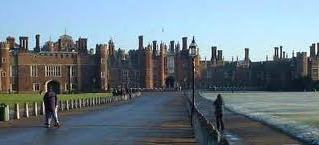
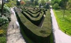
Hampton Court Palace front door to the centre of Hampton Court Maze |
Total Distance of 238.3 miles, plus bus journey of 6 miles to cross QE2 Bridge. |
|
|
|
Useful Links
Regional Links
Councils on Route in charge of Footpaths
Other Councils on Route
Extra Links
Copyright @ Sean.Davis 1995 - 2023 All rights reserved. (Last updated 25 March 2023)