 London
Green Belt Way
London
Green Belt Way 
London
Green Belt Way
[Home]
Stage 2
- Staines Pier to
Windsor & Eton Riverside
(10.55 miles)
Start: Grid
Reference TQ 03383 71448 Post Code TW18
4RH (nearest) StreetMap.
Mostly towpath
and parkland, there is a lot to see on this stage, so start early. The route
crosses Staines Bridge, then follows the Thames before crossing the road at
Runnymede. Note: The next 1.2 miles can be muddy when wet. We visit The Jurors,
and climbs up steps to the John F Kennedy Memorial. The acre of ground around
the memorial is officially part of the United States of America. We descend
again to visit Magna Carta Memorial and Writ in Water before climbing up to Air
Forces'
Memorial. Through Englefield Green. Soon the long trek through the Great Park
leads to and around Windsor Castle to finish at Windsor & Eton Riverside
Station.
To
start, continue upstream towards Staines Bridge. Soon over a wooden footbridge.
The wooden
footbridge was built in the mid-1980s and takes the Thames Path over the mouth
of the River Colne as it enters the Thames. It allowed a continuous path without
having to divert from the River Thames.
The statue down
steps, immediately past the footbridge and next to the River Thames is a Heron
carved from Portland Limestone by sculptor Simon
Buchanan
and named the
River Guardian.
It sits as a guardian overlooking and representing the river and is a benign
marker for river traffic and pedestrians on the Thames Path. It also provides a
peaceful place to get closer to the river and enjoy the boats cruising past.
Soon to the
right is
Thames Edge Court.
It has a bar and restaurants overlooking the river. It was built on the site of
the old ABC Cinema (aka Regal Cinema) and was completed in 2003. It contains 65
residential apartments with the food and drink outlets on the ground floor.
The Regal
Cinema was on the site of the now Thames Edge Court. It opened on 20th February
1939 and seated 1,103 in the stalls and 510 in the circle. It remained virtually
unaltered until the late 1960 when it changed name to the ABC
Cinema.
In 1971 it was converted to a two-theatre cinema and in 1972 to three theatres.
After the redevelopment in 1971, the cinema hosted the world premiere of the
movie "Up Pompei" starring Frankie Howard. It was taken over by the
Cannon Group in 1986 and renamed Cannon. From April 1993 to 1998 it was named
MGM. It was then taken over in a management buy-out and became ABC again.
However, with plans for a new multiplex to be built in the town, the old ABC
finally closed on 14th January 2001 and was demolished in August
2001.
In my first
years of knowing Staines, c1980, I remember that on the north side of the River
Thames, the towpath was not accessible from the bridge and you had to walk along
Clarence Street and then down the western side of the cinema to get back to the
river. If I also remember right, there was a pub next to the bridge and behind
the cinema. However, I have been unable to find information about this on the
Internet apart from the letters PH on old maps. Some locals tell me it may have
been called the Riverside Country Carvery Restaurant.
Immediately before Staines Bridge, turn right to go directly away from the river
along the path between the bridge and Thames Edge, soon climbing up some steps
to Clarence Street. At the top turn sharp left and over
Staines
Bridge
staying on the left-hand pavement.
Staines Bridge was designed by
George Rennie and his younger brother John. It was opened with great ceremony in 1832
by
William IV (formerly the Duke of Clarence and after whom Clarence Street at Staines
was named). This was the fifth bridge to be built here in fifty
years. The
previous four,
built 200m downstream from the current one, all failed. If you look closely, you
can still see an old bridgehead. The name
"Ad
Pontes"
("by
the bridges")
suggests in Roman Times at least two bridges crossed the river at Staines.
However, it may also refer to a bridge over the Thames and another over the
River Colne, which enters the Thames just downstream from the current Staines
Bridge (another theory comes later).
As with
previous bridges, traffic using the Rennie Brothers'
Bridge had to pay a toll to cross. This continued up until 1871, when to the
delight of local people and road users the toll was removed. However, I did read
at Staines Museum, that prior to 1878 every pedestrian was charged a toll of
half of one penny to cross Staines Bridge.
With the
outbreak of World War II, a wooden Bailey bridge was
built just upstream from Staines Bridge. Its purpose was to carry the extra
wartime traffic and to act as a spare if the main bridge was damaged by enemy
bombs. It closed to traffic 1947, but remained opened to pedestrians until 1959,
when widening of the main bridge had been completed.
After climbing
the steps, next to Staines Bridge, the pink building in front on the corner of
Clarence Street and Bridge Street dates from 1835. It was used as the
Literary and Scientific
Institution;
H G Wells is amongst those who lectured here. It was Staines first library from
1950 -
79 and is presently occupied by the
Showmens'
Guild. The
large
building
to the left of this (further along Bridge Street) was the headquarters of the
Courage Brewery Company (later Scottish Courage) and was aptly built on the site
of the old Ashby Brewery. Recently it has had a 14 million
pounds
makeover and has
been converted to offices
(see photo). The Ashby Brewery opened in 1783 and closed in 1930,
its original crown topped tower still stands close by on Church Street and has
now been converted to flats.
Immediately
south of Staines Bridge is a large roundabout. This is thought to be the site of
an ancient stone circle, sometimes called
"The
Old Stones of Staines"
and (from some sources) where the town is believed to get its name. The group of
nine stones is mentioned in the 12th Century charter of Chertsey
Abbey.
"Down to that Eyre that stands in the Thames at Lodders Lake and so along Thames by mid-stream to Glenthuthe, from Glenthuthe by mid-steam along Thames to the Huthe before Negen Stanes"
"Negen
Stanes"
is Saxon for "nine
stones",
"Glenthuthe"
is "Glanty"
(now an M25 junction at Egham) and
"Huthe"
is "Hythe"
(now
named
Staines Hythe).
On the other
side of the roundabout is a Sainsbury's
superstore. This was the site of Lagonda,
makers of motorcycles and cars. The company was started by Wilbur Gunn (1859
-
1919) a native of Springfield, Ohio who came to England in 1891. He was an
accomplished engineer and a keen opera singer. Through a local operatic group,
he met Constance Gray. She lived, with her husband, in a large house in
extensive grounds on the site. Constance was widowed in 1896 and the following
year she married Wilbur. He moved in with her and used their greenhouse as his
workshop for manufacturing small steam engines for riverboats. His introduction
to road vehicles was in 1898 when he made himself a petrol engine, which
attached to the front wheel of his bicycle, thus making it easier for him to get
about. After this he went on to produce more motorcycles. He named his company
Lagonda,
after his father's
engineering company back in Springfield,
"The
Lagonda Corporation".
The name originates from the Shawnee Indian name of a stream (now Buck Creek)
which flows through his hometown of Springfield. For the next seven years, as he
continued to produce motorcycles, the company expanded in the grounds of their
home. In 1905, the Lagonda works at Staines produced its first three-wheeled
car, and eventually went on to produce quality four wheeled cars. From 1914 to
1918, the factory was used to help with the British war effort. After the war,
it went back to making cars. Its most famous moment was in 1935 when a 4.5 litre
Lagonda, made at Staines, won the Le Mans 24-hour
race. In the same year, the company went into receivership, but was saved by
Alan Good who reformed it as LG Motors. During World War 2, production once
again turned over to the war effort. After the war, car production recommenced
and continued until 1948 when David Brown bought the company, merged it with
Aston Martin and moved work to Feltham. The Staines factory was sold to
Petters, a diesel engine company, who retained it until 1989
when the site was sold to the supermarket company.
After
crossing Staines Bridge turn left into The Hythe. After 140 yards go straight on
past Chertsey Lane to the RHS.
The Hythe
is a street of well-preserved old buildings, with many dating back to the 17th
Century and before. They include the
Swan Hotel,
parts of which date from the 15th Century with its cosy bar and beer
terrace overlooking the river. Just across the street are the 16th
Century
Ann Boleyn Hotel
and the
Jolly Farmer Pub.
As you descend
into The Hythe an information board, on a wall on the right, next to and old
George V postbox, gives more details about the history of this small area.
"Hythe"
means a "landing
place on a river, inland port".
An archaeological excavation in the grounds of the Ann Boleyn Hotel revealed a
settlement here during Roman Times. It is known a port had been established by
the 7th Century. For centuries bridges crossed the river here until
1832, when the current bridge was opened a short distance upstream. After then,
The Hythe became less important as through traffic was diverted away and due to
this the old buildings here have been preserved.
To the left,
after passing Chertsey Lane, is a house named
Ye Olde Bridge Cottage.
This was built c1791 as a toll-house for a new stone bridge across the river. It
was built on the site of an older inn named The Swan. However, the stone bridge
soon developed cracks and was replaced by a metal bridge. This also failed and
by 1808 the Government admitted defeat and reverted to using the old wooden
bridge, which luckily had not yet been demolished. The abutment of one of the
two failed bridge remains as part of the river wall. When the present Staines
Bridge was opened in 1832 it was obvious the toll-house would no longer be used
for its original use and was sold. Today it still stands as a private residence.
Also, soon after 1791 a new Swan Inn was built 50 yards upstream from the site
of the older inn. This now still exists as The Swan Hotel.
To our right
along this part of The Hythe are some beautiful old houses. The first few form a
red-brick terrace dating from 1755. Numbers 23 & 24 are quite unique with three
fire marks on the front wall. This meant they were insured if their house went
on fire, and the local fire service would come to your rescue and try to save
your house. Just past this, the row of three cottages (22
-
20) were built in 1640 and retain many of their original features, including
original fronts, sash windows and beamed ceilings. The centre of the three is
named "Boatman's
Cottage"
and this possibly provides an insight into their origins. The last house on this
side of the street (No. 17) also has a fire mark on the front wall of the house.
Like many of the buildings in this small area, all are grade II listed as being
historical buildings.
At the
end turn left on a path to the river, then left along the path next to the river
(now to your RHS). Soon past the
back of The Swan
Hotel,
then eventually over an old footbridge and under Staines Bridge and westwards.
Shortly after
passing under Staines Bridge the towpath crosses over a
footbridge,
to the left is a small marina with possibly a bit more potential than it's
used for at present. Soon after this, a path to the left leads to River Park
Avenue and the car park of Homebase and Halfords. In Spring and Summer, a
burger van
is usually resident here next to the towpath. Next to the towpath is an old
coal & wine tax post.
Across the river is Church Island.
The island has a few houses and is connected to the north bank of the river by a
footbridge. Many years ago, barrels of beer from the Ashby Brewery were
transported here by chain ferry, then taken across the island and loaded onto
boats. The old chain ferry, although looking a bit sad for itself, is still
moored to the north side of the island.
Some sources (Wikipedia
is one)
suggest "Ad
Pontes"
referred to a crossing of the river via Church Island, where one bridge ran from
the north bank of the Thames to the island and a second spanned the main stream
of the river from the island to the south bank. On studying maps, this is a real
possibility as the old A30 into Staines High Street, just before the current
pedestrian zone, veers in the correct direction. However, shortly before
reaching the Thames, the route would still have had to cross the Colne and thus
suggest three bridges. Whichever theory is correct, it is clear an important
Roman Road ran from Holborn along Oxford Street, joining what is now the route
of the A402 through Shepherds Bush, the A315 along Hounslow High Street, and
then the A30 to and through Staines and onto the Roman town of Calleva Atrebatum
(aka Silchester). Staines was a day's
march from London and would have been the stopping point before another day's
march to
Silchester.
Calleva Atrebatum
(Roman for Silchester) and London were both major Roman Towns and this also
indicates Staines was hugely important at the time. Today it is still easy to
follow this Roman route from London to Staines on modern maps (e.g. this map
from
Saxon History)
and it shows how towns still exist along this old road - their most important
streets still line the route. I have studied this old road for many years,
mostly on the Internet and sometimes on the ground. I have
my suggestion for a route,
but the actual route from Staines to Sunningdale is still highly debated.
Due to the
Roman history of Staines, it's
not surprising that in the
Domesday Book
of 1086, Staines is recorded as a very large settlement with 140 households and
six mills.
After
Church Island,
on the opposite bank, is Lammas Park (on some maps named Ashby Recreation
Grounds) and it was here on the riverbank where the
London Stone
sat from the 18th century until it was replaced by a replica in 1986.
In 2012, the replica was moved back down river to where it now sits, between the
Town Hall and the Town Pier, and near to its original site.
To the left of
the towpath is an industrial park, mostly owned by British Gas and it was from
here where the nations gas bills were issued for many years.
Within a short
distance, across the river, although not obvious as an island, is
Holm Island.
It's
a wooded place with a house called
"The
Nest",
apparently a courting place in the 1930's
for
King Edward VIII
(later the Duke of Windsor) and Mrs Wallis Simpson, an American divorcee. Edward
was the second member of the House of Windsor to become Monarch. His father
(King George V) with German roots (Saxe-Coburg)
got rid of the German family name in 1917, during of World War I, and chose a
very English name for the Royal Family (Windsor sounded good and still continues
to be their family name).
Edward VIII
abdicated the throne of England on 11th December 1936, less than 11
months after he became monarch. He could have fought to keep it, but the Prime
Minister at the time, Stanley Baldwin, put too many obstacles in the way and
would not allow him to marry a divorcee. It was one of the great romances of the
20th Century, but it almost brought the English Royal Family to its
knees. He was made Duke of Windsor, and married Wallis at Chateau de Cande, near
Tours in France on 3rd June 1937. Edward spent most of the rest of
his life in France, and until the day he died was not forgiven by his family.
Edward died on 28th May 1972. He is the only monarch to have ever
voluntarily relinquished the throne of England. He is buried at Frogmore in the
Home Park at Windsor, which we pass later in this stage. Wallis
-
the
Duchess of Windsor
-
died on 24th April 1986, and is buried next to her husband.
The
towpath passes under the bridges carrying the M25 and the A30. The road bridges
are only separated by three metres and together tower overhead for 80
metres. From here, continue straight on along the towpath for a mile to and
around the Runnymede Pleasure Grounds.
Just before
going under the M25 the Thames Towpath passes over two footbridges within 150
yards of each other. The footbridges (photo
1,
photo 2)
take us over small streams entering the Thames from our LHS.
The
M25 Road Bridge
was opened in 1985 and the A30 Road
Bridge in 1961. The latter was designed over 22 years earlier by
Sir Edwin Lutyens,
but due to the outbreak of World War II it was delayed. During the construction,
archaeologists uncovered a
Bronze Age (2200 BC to 750 BC) settlement site, which overlaid
a much older
Neolithic (4000 BC to 2200 BC) site. Some of the findings from
the site can be seen at the
Spelthorne Museum.
Immediately
after the road bridges the Colne Brook stream joins the Thames across the river
to the right.
In front is
Bell Weir Lock
and on the left overlooking the towpath is the
Runnymede Hotel.
The hotel was used as the venue for a party where
Team GB
(the 2008 British Olympic Squad) celebrated their success after returning from
the Beijing Games in 2008.
In January 2014
many places next to the River Thames flooded. The large flat floodplain at
Runnymede went under water. The Runnymede Hotel was badly affected and the road
was closed. There are many videos available from the time. This one on
YouTube also cover Staines.
Soon some
pleasant riverside properties appear on the opposite bank, and shortly after the
first few, part of the river branches off to form an island. This is at Hythe
End, Wraysbury, is simply called
"The
Island",
and is again lined with pleasant houses overlooking the main stream of the
river.
The towpath
soon passes the
Wraysbury Skiff & Punting
Club
(at 2 miles) before following the river around the open meadow of the
Runnymede Pleasure Grounds.
The
area
is a pleasant and peaceful setting and offers many facilities, including a cafe,
toilets, parking, a
paddling pool,
a playground, information boards, and
boat trips
up the river to Windsor. On a warm sunny day, it is an ideal place for a family
picnic, to play by the river, or to start a walk from.
At the time of
writing this (2020), there are exciting new plans here to make this area more
friendly for users and develop more access paths. Let's
see what happens.
To the left,
shortly before exiting from the Pleasure Grounds, is a
statue
of Queen Elizabeth II. It was unveiled on 14 June 2015 by the then Speaker of
the House of Commons, John Bercow, to commemorate the 800th
anniversary of the sealing of Magna Carta. You can read about the event at
BBCNews.
At the
end of the pleasure ground, follow the towpath as it turns right through a
kissing gate (the gate maybe gone
-
see
photo)
and adjacent to the road
-
the river is to your RHS.
Across the
road, to the LHS, is a wide-open meadow with
Coopers Hill in the distance. After
another 400 yards, look right, across the river and through a gap in the trees
on the opposite bank of the river to see the remains of the
Benedictine Nunnery
of Ankerwycke. It
was founded c. 1160 AD by Sir Gilbert de Montfichet in honour of St. Mary
Magdalene in the reign of King Henry II. This is now an area of parkland
acquired by the National Trust in 1998 and as well as the remains of the nunnery
you can also see, the ancient
Ankerwycke Yew.
The
view
of both from here were sketched twice by Turner and are held by The Tate.
The
Ankerwycke Yew
is a magnificent tree believed to be over 2,000 years old. There are many myths
about the tree and some believe it to have holy and even magical powers. It is
thought to have been a meeting place for Druids and today is usually covered
with ribbons and other gifts left by pagans. It even gives its name to a local
pagan group called
The Circle of Ankerwycke.
Tradition says the tree is where Henry VIII courted Anne Boleyn in the 1530s
whilst he was still married to Catherine of Aragon.
It is also
believed many hundreds of years ago the Thames changed course in this area and
originally flowed north of both the tree and the nunnery. Both sit on Ankerwycke
Island formed by a small stream of the Thames
The name
Runnymede translates as a broad riverside meadow. It was where
King John sealed
Magna Carta
on 15th June 1215. John came to power after the death of his brother
Richard the Lionheart
in 1199. Richard's
roots were Norman and he was popular in both France and England. He had
nominated
Arthur of Brittany
as his successor, but John seized the throne of England for himself. John was
unpopular in France and was forced to fight for his lands there. He captured
Arthur during one battle, and soon Arthur was mysteriously killed, he was just
16 years old. It is believed John himself was the murderer.
These wars
drained John's
purse and were financed by higher taxes on the English, especially the nobles.
He did as he pleased and, in the process, he came at odds with the Pope and his
own Barons. The nobles in England were fed up with his actions, and led by
Robert FitzWalter, they decided he needed a bit of a slap on the wrist.
Within a couple
of years, the Barons assembled their forces and took over London. They put the
King into a corner and decided to make him surrender some of his powers. About
60 barons were involved. A document believed to have been drawn up by Stephen
Langton, Archbishop of Canterbury, was thrashed out by the opposing sides. This
document named
"Magna
Carta"
was signed by the King and the Barons and witnessed by the clergy, including
eight bishops. It was basically the first-time
common people were given rights and meant the King could be questioned over his
actions. In the stand-off to the signing, the King and his supporters were based
at Windsor and the Barons at Staines.
Twenty five nominated Barons
met halfway, at Runnymede where the King had no choice but to seal
"Magna
Carta".
As a stipulation in the agreement, a few days later the Barons re-proclaimed
their loyalty to the King. However, the document did reduce the king's
powers and it was the first which made a King of England accountable for his
actions. It is believed King John camped with his followers next to the old
Ankerwyke Yew on the night before the signing of Magna Carta.
Through the
years, the charter formed the basis of an individual's
right to justice and liberty. Many modern day constitutions, including that of
the USA and its
Bill of Rights
are based on the charter. A
Magna
Carta
Memorial presented by the American Bar Association in 1957,
stands at the foot of Coopers Hill and can be seen to the left in the distance.
There are four surviving original copies of the Magna Carta; two are at the
British Library while Salisbury and Lincoln Cathedrals each hold one.
No one can be
100% sure of the exact spot where Magna Carta was sealed. Some think it may have
been on Magna Carta Island, some think it was on the broad meadow below Coopers
Hill, but according to some other old references, mainly on
www.wraysbury.net/history/magnacarta.htm
(link broken), it seems most likely the signing took place next too, or under
the Ankerwycke Yew. The Wraysbury website is worth a visit and contains some
well-researched information about the Magna Carta, the yew tree and the local
area. It appears some of their information came from an old book which I read a
few years ago, but am now unable to find at present. Nowadays, even
The National Trust
believe the old yew tree has a claim to the site where Magna Carta was sealed.
Below is a poem
written by
Joseph Strutt
(1749 -
1802) and covers some of the events which happened at Runnymede.
"What
scenes have pass'd,
since first this ancient Yew
In all the strength of youthful beauty grew!
Here patriot Barons might have musing stood,
And plann'd
the Charter for their Country's
good;
And here, perhaps, from Runnymede retired,
The haughty John, with
secret vengeance fired,
Might curse the day which saw his weakness yield
Extorted rights in yonder tented field.
Here too the tyrant Henry felt love's
flame,
And, sighing, breathed his Anne Bolyn's
name;
Beneath the shelter of this Yew-tree's
shade,
The royal lover wood'd
the ill-star'd
maid;
And yet that neck, round which he fondly hung,
To hear the
thrilling accents of her tongue;
That lovely breast, on which his head
reclined,
Form'd
to have humanized his savage mind;
Were Doom'd
to bleed beneath the tyrants steel,
Whose selfish heart might doat, but
could not feel.
O had the Yew its direst venom shed,
Upon the cruel
Henry's
guilty head,
Ere Englands sons with shuddering grief had seen
A
slaughtere's
victim in their beauteous queen!"
On the 15th
June 1992, 777 years after the signing of Magna Carta another group of people
met at the old yew tree to make an oath. This was called the
Green Magna Carta. It was drawn up by
botanist
David Bellamy
and its intention was to work towards an eco-friendly future.
In June 2002, a
plaque, next to the Ankerwyke Yew, was unveiled by
"The
Tree Council"
-
it reads:
IN CELEBRATION OF
THE GOLDEN JUBILEE OF
HER
MAJESTY
QUEEN
ELIZABETH
II
has designate
THE
ANKERWYCKE
YEW
one of fifty
GREAT BRITISH TREES
in recognition of its place
in the national heritage
JUNE
2002
Supported by National Grid"
If you walk along the path around
Ankerwyke Island looking for the tree, unless you know your
"yews",
this plaque at the side of the path is the best way to find the tree. It's
only when you follow the small path next to the plaque and under the tree you
see what is special and get an appreciation of the tree's
age. The tree trunk has a massive girth of 32 feet and one can only look with
amazement at its shape and think of the history it has witnessed. At 2.65 miles
into the stage if you look directly across the River Thames, the old yew tree is
in a straight-line
set back almost 200 yards past the opposite bank
-
I'm
not sure if you can see it, but you should be able to see the ruins of
Ankerwycke Priory.
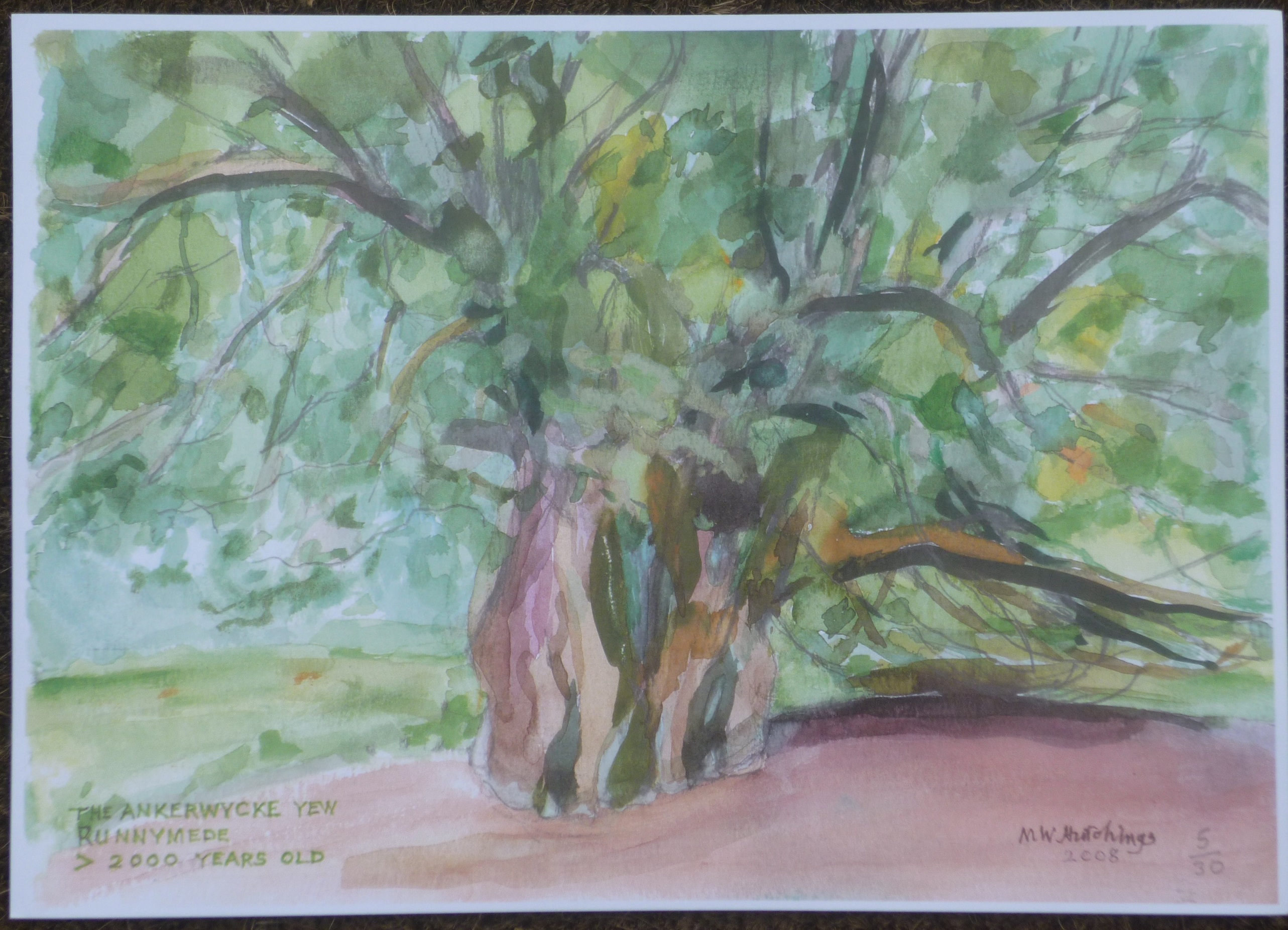
In 2008,
Mike Hutchings at the young age of 88 painted a wonderful
watercolour of the tree. He has been involved in the long-distance relay around
London since its inception in 1994, initially made me take an interest in the
history of the places we passed, and still continued to run with Stragglers
Running Club well into his 90s. You can download a copy of his painting
HERE.
Two videos on
YouTube about the tree are worth a visit:
1.
Notable Trees of the
National Trust - The Ankerwyke Yew,
by National Trust Charity.
2.
The Ankerwycke Yew
- an ancient living legend,
by Sarah Rees
To the left at
the top of
Coopers Hill
and above the Magna Carta Memorial is
the striking
Air Forces Memorial.
We'll visit it later in this walk.
Follow
the towpath between the road and the river for 0.9 miles to just after one of
two red brick lodges
- one is
on either side of the road.
Across the
River Thames from 2.65 miles to 3.1 miles is
Magna Carta Island
with a large private house near its western tip. It is difficult to distinguish
the island, as the stream behind it is very narrow. The island also holds claims
to be the place where Magna Carta was sealed. The house was built in 1834 by
George Simon Harcourt, Lord of the Manor of Wraysbury. It has a specially
designed Charter Room with a stone topped table as its centre-piece
and the coats of arms of the 25 Barons. There are claims this is the stone on
which Magna Carta was sealed. A few years ago, the island, including house and
stone, was sold for 4 million
pounds. You can read about this at
BBC
and watch a promotional video for the sale at
YouTube.
Immediately
after the island, the gardens of a few desirable residents back onto the
opposite bank of the river, some of which are hidden by
Pats Croft Eyot.
The
towpath passes through some trees, between the red brick lodge and the river,
and soon comes out to a small car park at the Runnymede Boathouse. Turn left
towards the road and cross straight over (with care) and into the National Trust
car park on the opposite side. Turn left through the car park to the second red
brick lodge -
you may choose to stop here for refreshments.
The Runnymede
Boathouse is owned by
French Brothers,
who run boat trips from here downstream to Staines and on to Hampton Court and
upstream to Windsor.
Over the years
the historical significance of Runnymede became less known. In the 18th
and 19th centuries it was more famous as a venue for the Egham Horse
Races and as a consequence became protected as an open space under the Egham
Enclosure Act of 1814. The races stopped in 1884 and by the early 20th
Century the site was under threat again. In 1921 the Liberal-Conservative
coalition, under David Lloyd George, proposed to auction Runnymede to raise
extra funds for the Treasury. However, due to public outcry this did not go
ahead. In 1929 Lady Fairhaven bought 188 acres of this area for the memory of
her recent late husband Urban H. Broughton MP (1857 - 1929) and Runnymede was no
longer under threat. He was just about to be made a Lord before he died. She was
created Lady Fairhaven and their oldest son Lord Fairhaven. She commissioned the
great architect Sir Edwin Lutyens to build two lodges and plinths at the Old
Windsor side and two kiosks and plinths at the Egham side as a memorial to her
husband. Two years later, in 1931, she gifted the whole site to the
National Trust
and saved this place for the nation. The Lutyens'
lodges, one on each side of the road, were officially opened in 1932 by the
Prince of Wales (who later became Edward VIII). The first lodge we passed, did
contain the Runnymede Art Gallery and, as far as I can gather is now a National
Trust office. The second has a tearoom, small information centre and shop.
As for the two
kiosks, at the Egham entrance to Runnymede, we didn't
see them on our walk as we were on the Thames Path when we passed them. To see a
photo of one of them follow
the link.
From
the lodge find your way to the entrance of the car park. By the entrance is
wooden shelter with information leaflets and a map. From the map you'll
get a good idea of where you are going next.
A
finger-post
signed "Memorials"
points across the meadow. There are two well-defined
paths, follow the left of the two paths.
After 200 yards the path leads to an art sculpture entitled
"The
Jurors".
This was commissioned by Surrey County Council and the National Trust. It is 12
bronze chairs on the meadow at Runnymede representing the 12 people who sit on a
jury in the UK. Each chair is engraved on the front and back with people's
fight for justice, human rights and freedom since ancient China, through the
signing of Magna Carta in 1215 and up to how modern technology and the Internet
affects bullying and freedom of speech in the present day. They depict times and
places where ordinary people had no rights; slavery, those thrown over-board
to drown and claimed as lost cargo by their wealthy
"owners";
women, ethnic and gay people fighting for equal rights; momentous moments in
history; France becoming a republic, big business polluting the world; people
such as Nelson Mandela, Mahatma Gandhi and Aboriginal Australians fighting for
the rights of their people. This is a beautiful sculpture and you can read more
at
National Trust.
The Jurors was created by Hew Locke, according to his
website:
"The Jurors is a permanent artwork designed for this ancient landscape to
mark 800 years since the sealing of Magna Carta in this place. It is formed of
12 bronze chairs, each decorated with panels of images and symbols relating to
past and ongoing struggles for freedom, rule of law and equal rights. The Jurors
is not a memorial, but rather an artwork which requires people to complete it.
The chairs awaiting a gathering, discussion or debate of some kind: an
open invitation for the audience to sit down on them, to reflect and discuss
together the implications of the histories and issues depicted, and to debate
the meaning of justice..."
To watch a video on how the sculpture was made see
YouTube.
You can also watch short documentary video containing thoughts from the artist
also at
YouTube.
From
"The
Jurors"
take the diagonal path south towards the trees. After 100 yards you reach the
trees and a wooden kissing-gate. Go through the
kissing-gate
to climb steeply up stone steps. On reaching the JFK Memorial walk past it and
along the terrace to The Seats of Contemplation.
After passing
through the kissing gate, you are officially stepping onto American soil. In
front are the 50 steep steps, which climb too and lead past the
John F Kennedy Memorial.
The steps are named "The
Steps of Individuality"
and are made of 60,000 individual axe-hewn Portuguese granite setts which rise
steeply through the woodland. Each step represents a state of the USA.
The centre-piece of the John F Kennedy Memorial is a
large engraved slab of Portland stone designed by Geoffrey Jellicoe. It was
unveiled by HM Queen Elizabeth II on 14th May 1965 in the presence of
President Kennedy's widow, their children, and his brothers. By visiting the
links to
YouTube1,
YouTube2 you can watch a short video of the ceremony. For a
longer video of an insight of the architect design thoughts click
HERE.
In her speech the Queen proclaimed:
"This acre of English soil is now bequeathed in perpetuity to the America People
in memory of President John Fitzgerald Kennedy, who in death my people still
mourn and whom in life they loved and admired."
The memorial is
not just the stone slab, it is also the steps, the different trees planted here,
the terrace walk and the two seats of contemplation at the end of the terrace.
There is a lot going on here, but it's
probably best for you to read all of this at the
Kennedy Memorial Trust.
Retrace
your route back down the steps and at the bottom go through the wooden kissing-gate
again. Turn right along a line of trees to your RHS. After 160 yards turn right
through a wooden gate to visit the Magna Carta Memorial.
Just through the gate are two information boards and
directly ahead
is the
Magna Carta Memorial (at 4 miles). This monument was designed by Sir
Edward Maufe and erected in 1957 by the American Bar Association. It is nestled
in trees, up a gentle slope and overlooking the meadow and the River Thames.
After
visiting the memorial, retrace your steps to exit the wooden gate. Turn right
signed Air Forces'
Memorial (and possibly Writ in Water). To help with direction finding there are
3 marked walks and for the next 0.8 miles we follow the purple route to the Air
Forces'
Memorial -
see
LINK
for a good map which can be enlarged.
After
just 20 yards go through a kissing-gate and veer right between trees. After 300
yards you reach a round building named
"Writ
in Water".
According to the National Trust
website:
"Writ in Water, a major architectural artwork by Mark Wallinger, in collaboration with Studio Octopi, provides a new immersive space for contemplation and reflection at Runnymede, Surrey. Writ in Water is open seven days a week ... and is free to enter..."
"The large-scale circular building emerges from the hillside at the base of
Cooper's Hill. The meadow it sits within is flanked by the River Thames on one
side and an ox-bow lake on the other, itself a trace of the river's earlier
course.
Responding to this feature of the landscape, Writ in Water takes its name
from the inscription on John Keats' gravestone, which reads, 'Here lies one
whose name was writ in water'.
Built in cubits, the most ancient unit of measure, and using rammed stone
from the site itself, Writ in Water sits at the heart of this ancient land.
An exterior doorway leads to a simple circular labyrinth, in which the
visitor can choose to turn left or right to reach an inner doorway that opens
out into a central chamber. Here the sky looms through a wide oculus above a
pool of water, as reflective as a still font.
The sides of the pool are inscribed on the inner side, the water
reflecting (much like the seal on Magna Carta itself), the reversed and inverted
lettering of Clause 39 as the visitor moves round the pool to reveal its
words."
To watch a National Trust video entitled Creating
"Writ
in Water"
by Mark Wallinger, at Runnymede, follow the link to
YouTube.
After
visiting "Writ
in Water"
continue to follow the path along the line of tree to your RHS and soon into
trees. Then after just a short distance turn right and uphill following purple
markers towards Air Forces'
Memorial.
This path is steep, wooded and there are some steps. I last visited in early
2015 and it was wet and slippery in parts. There was also a community of Eco
Warriors living here. They were very friendly, but were moved on soon
afterwards.
After
climbing steeply for almost 200 yards, we cross another path and soon after veer
left, continues to climb, but not as steep, and in another 220 yards leads out
onto Cooper's
Hill Lane.
Turn
right along the lane for 200 yards, to after university halls of residence,
then turn
right to stay along Cooper's
Hill Lane.
After
50 yards turn right to visit the Air Forces'
Memorial. After visiting, retrace your steps to the entrance and turn left along
Cooper's Hill Lane.
The Air Forces'
Memorial was designed by Sir Edward Maufe R.A. and unveiled by HM Queen
Elizabeth II on 17th October 1953 (see
video). It was the first World War II building to be
listed for architectural merit. It is administered by the
Commonwealth War Graves
Commission.
From the top of the tower, visitors can see Windsor Castle, Runnymede and
breathtaking views over seven counties. It is a tribute to
"the
men and women of the Airforces of the British Commonwealth who lost their lives
in the Second World War and who have no known grave".
There are 20,275 names carved in the stone walls and floors.
As the
lane turns left, veer right
immediately before a cream building dated 1889 and at entrance to
drive veer right past gate-post and onto enclosed footpath.
After
280 yards the path turns right and then soon turns left. It eventually comes out
to a road (Tite Hill). Cross straight over and onto an enclosed footpath. The
footpath leads to a road (Middle Hill). Turn right and just after a few yards
cross over into Barley Mow Road.
Follow
Barley Mow Road for 400 yards until it comes out onto St Jude's
Road (A328). Cross straight over and turn right, then left (still Barley Mow
Road). Cross over onto Englefield Green and follow the LHS of
"The
Green"
past the Barley Mow Pub and then past the cricket ground.
Eventually "The
Green"
leads to a T-junction
with Bishopsgate Road. Cross over and turn left along the pavement.
By now you may have noticed there are many large and very private houses hiding
behind gates and between the trees.
Englefield Green
covers a large area. According to
Chertsey Museum,
it takes its name from
"Inga's
Feld".
Inga meaning
"people"
and
"Feld"
was a large grassed area used as pastural land by the community. The term
probably dates back to a least Saxon Times. The name Green was added in the 17th
Century. The village has three distinct areas: the north and west is made up of
part of Windsor Great Park and large private manors; the built-up
southern area, and in the middle is The Green. Under the Egham Enclosure Act of
1814 much of the land was sold to private buyers who built large houses here
because of the proximity of the Royal Family at Windsor. The Act also protected
The Green which is Crown property and leased to the
Residents for the use of the
community. The growth of the built-up
area to the south was greatly influenced by the opening of Royal Holloway
College in 1886.
The
road soon curves around to the left, and after 300 yards crosses over the
entrance to Castle Hill Road (at 6 miles).
At the far end of Castle Hill Road is Priest Hill. This is the site of the last
place a
fatal duel was fought in England. It took place in 1852 between two French
exiles. There are many accounts of the duel on the Internet. The one below is
from the
Englefield Green
section on Wikipedia.
"The last fatal duel in England took place on Priest Hill in 1852. It was between two French refugees, Lt. Frederic Constant Cournet and Emmanuel Barthelemy. Cournet was supposed to have been the better prepared for a sword duel. Barthelemy, an extremely questionable individual (responsible for at least two murders by 1852), manipulated Cournet into challenging him (supposedly over comments Cournet made about Barthelemy's girlfriend), and chose pistols for the weapon. He killed Cournet, and was subsequently arrested for murder. However, Barthelemy managed to convince the jury it was not a homicide as in the normal sense of the word, and was acquitted. Barthelemy was widely suspected of being a spy for the new French regime of Emperor Louis Napoleon (Napoleon III). In fact, his bullying of other refugees had led to the confrontation with Cournet. However, three years later, he was engaged in a crime in London, possibly involving a blackmail attempt that did not work out. Two men were killed, and Barthelemy was arrested. Despite giving an image of bravado in court, this time he was convicted, and subsequently hanged. Most criminal historians and writers feel he was a totally repugnant character, but to be fair he had one odd defender: Victor Hugo, who wrote a small panegyric to his memory in one of the later sections of Les Miserables. Cournet is buried in Egham parish church graveyard."
Continue straight on along Bishopsgate Road, staying on the pavement on the RHS.
After
0.43 miles cross over Crimp Hill, then follow Bishopsgate as it veers right and
past Wick Lane (to
your LHS).
To the left, just after Crimp Hill, and hidden from view, is the luxury Savill Court Hotel (now Fairmont Windsor Park). The house here was originally a Jacobean Manor named "The Dell" and was acquired by Baron Sir John Henry Schroder (of Schroder's Bank) in the late 19th Century. He extended the house greatly for the use of his family. Baron Schroder died in 1910 and is buried in Englefield Green cemetery. The house and his title passed onto his son Bruno Schroder who died in 1940 and is also buried at Englefield Green. During World War II, it was used as a military hospital. It remained in the hands of the Schroder family until the early 1980s. The manor was then refurbished, extended, and opened as the Anugraha Hotel in 1984. Its name later changed to Savill Court Hotel, the name coming from the neighbouring Savill Garden. The hotel now sits in 40 acres of grounds. The rebranded Fairmont Windsor Park opened 1 January 2022.
Immediately
past to the entrance of the
hotel is
Wick Lane. The lane runs south along
the western edge of the hotel grounds and past the Savill Gardens to Egham Wick.
In 1956, in Parkside House, on the west of the lane is where
Marilyn Monroe
spent her honeymoon and an extra four months with her new husband
Arthur Miller
whilst filming
The Prince and the Showgirl
with Laurence Olivier.
The newly wedded couple were often seen cycling along Bishopsgate and through
Windsor Great Park. At the time not many locals knew it was Marilyn, some told
stories of seeing someone who looked just like Marilyn Monroe cycling past them.
Shortly after
Wick Lane, on the left along Bishopsgate and just before Windsor Great Park, is
the
The Fox & Hounds
Restaurant & Pub.
This is a pleasant English country pub dating from c1780. It has a beer garden
to both the rear and the front, and a good place to stop for some local real ale
from the
Windsor & Eton Brewery.
At the
end of the lane is Bishop's
Gate, the entrance to
Windsor Great Park.
Go straight on through the gate, on the right is the gatekeeper's
box (small wooden office) and on the left is their cottage. Stay straight on
along the road towards a gate and two pink gatehouses.
After
230 yards, at a crossroads, turn right. This leads to a metal kissing gate. Go
through the kissing gate and into the Deer Park.
The original
park is thought to date back over a thousand years to Saxon Times. In the 13th
Century, the Norman rulers enclosed the park. They introduced deer and wild boar
and used it as a royal hunting ground. Successive monarchs used the park in this
way and even today, although the wild boar have long disappeared, the deer still
need to be culled to keep numbers manageable and end up on the royal dinner
table or in the estate farm shop. In total, the great park covers about 5,000
acres and is the only
"Royal
Park"
still managed by
The Crown Estate.
Most of it is open to the public and within its boundary are many places of
interest. A village built in the 1930s still houses many of the estate's
workers. There are the Guards Polo Grounds at Smiths Lawn; Virginia Water Lake
to the south, man-made
in 1753, has a 4 mile walk around its shores with many things to see along the
way; the enclosed Deer Park which our route has just entered; the Savill Garden;
the Valley Gardens; many royal lodges, and trees dating back to over 1,000
years;
Follow
the traffic free road through the park for half a mile, until just over a stone
bridge. Then veer left onto the grass and follow a worn path uphill, past trees
to your LHS and to The Copper Horse.
The
Copper
Horse
sits on the top of Snow Hill. It's
only when you get close that you appreciate how huge it is. The bronze statue
depicts George III (reigned 1760
-
1820) on horseback with his hand pointing towards his favourite residence,
Windsor Castle. It was commissioned by his son George IV. The sculptor,
Richard Westmacott, took a few years to complete the work
and when erected in 1831, it had to be done in sections due to the size. The
king is portrayed as a Roman emperor, wearing a tunic and with no stirrups.
Westmacott is also said to have been influenced by an earlier equestrian statue
of Peter the Great, the Bronze Horseman, which stands in Senate Square, Saint
Petersburg, Russia, After writing this I discovered George IV died a year before
it was erected, I just hope he had already paid for The Copper Horse.
On a clear day, the view from Snow Hill is claimed to be one of the best in the
country and yet, even on a beautiful day, this place is hardly ever busy. It's
probably because you can only get here by horseback or under your own power. As
well as the magnificent view of Windsor Castle, you can see along the Thames
Valley, the Staines'
reservoirs, the planes taking off and landing at Heathrow Airport, the arch at
Wembley Stadium and the tall buildings of Central London, to name just a few.
From
The Copper Horse, walk down the hill and then along the tree lined
Long Walk,
and continue straight for almost 2.4 miles to near the castle at the other end.
You can walk on the grass if you wish.
The
Long Walk
was started by Charles II who had a double avenue of Elm trees planted between
1680
and
1685. Queen Anne added the central carriageway in 1710. However, most died
and were replaced by young Elms from the castle to where the gates are now, next
to Park Street. Beyond that the soil was found to be unsuitable for Elms so were
replaced by a line of Horse Chestnuts and one of London Planes.
After
1.15 miles, a large gate blocks the Long Walk. To the side a pedestrian gate
gives access to continue. The gate is there to keep the deer at bay and marks
the southern boundary of the Deer Park.
0.45
miles later, the Long Walk crosses the busy A308 and to the left are some old
estate workers cottages. Cross over with care and continue towards the castle.
Once over the
A308 the park changes name to
The Home Park.
This is the monarch's
own park and most is to the right and hidden behind a metal fence. The area was
closed off as a private park with the passing of
"The
Windsor Castle and Town Approaches Act"
by Parliament in 1848. The private part of the park contains many places of
interest including:
Frogmore House;
Frogmore Cottage;
the
Royal Mausoleum
(visible from the Long Walk and the resting place of Queen Victoria and Prince
Albert -
see
video);
Adelaide Cottage;
the Royal Household Golf Club (only open to members of the royal family and
their staff); the
Royal Household Cricket Club;
Home
Farm and the
Windsor Farm Shop.
On Saturday 19
May 2018 Windsor was home to the
Royal Wedding
of Megan Markle and Prince Harry (Wikipedia
has a very detailed section on the wedding). They were married in St George's
Chapel at Windsor Castle. They then were escorted in an open horse-drawn
carriage through the streets of Windsor and along The Long Walk from the A308
and back to the castle. An estimated 110,000 people lined the route. You can
watch the procession at
YouTube. Luckily, it should be a bit quieter when you walk
along this section of The Long Walk towards the castle.
0.82 miles after the A308, on approaching the castle, Cambridge Gate blocks the Long Walk. However, there is still a magnificent view of the state apartments (now at 10 miles). At this point, turn left to leave the park via Park Street Gate and into Park Street.
Before you
leave The Long Walk turn around and
look back
to the statue of King George III in the distance. It looks so imposing and
difficult to believe it's
2.4 miles since you passed it on top of Snow Hill.
Just into Park
Street on the right is the
Two Brewers
public house. This 17th Century pub has low ceilings, many artifacts
on its walls and two bars
"This
Bar"
and "That
Bar".
The history section of
the Two Brewers website is well researched and worth a read.
Park Street,
Windsor, is mainly residential and full of 17th & 18th
century buildings. Some were once coaching inns and some
coaching arches
remain. The prices of houses in the street can be extortionate and many have
been converted to offices. Up until the closure of the Home Park in 1848, this
was the main road out of Windsor towards London.
At the
end of Park Street and just before the High Street, turn right into St Albans
Street.
To the left
near the junction of the two streets is a
blue mailbox
dating from 1911 and possibly the only one in the UK. It was erected for the
world's
first postal airmail service. This took place between Windsor and Hendon and was
to celebrate King George V's
coronation.
Next to it
are two red mailboxes, an old red phone box and an ancient well.
Just a few yards in front of all this Royal Mail memorability is a bronze statue of a soldier - the Irish Guardsmen Memorial.
To the right on
entering St Albans Street is the
Royal Mews with its
exhibition of state coaches. Just past this is Burford House, built for
Nell Gwyn
in the 1670s. On her death (4th November 1687) the house passed onto
her son
Charles Beauclerk, Duke of
St Albans
an illegitimate son of King Charles II and from whom the street gets its name.
It now houses a collection of gifts presented to the royal family. Charles II
had many mistresses and produced many illegitimate children as a consequence.
Two notable people descended from these include,
Diana, Princess of Wales
(bloodstock from four of his children), and
Camilla,
Queen Consort.
On the left
half way along St Albans Street is the Parish Church of
St John the Baptist.
This was built in 1822 and replaced an older part Saxon and part Norman church.
Just past it is the entrance to Church Lane.
Near the end of
St Albans Street a
blue plaque
on the castle wall states,
"From 1785 to 1788
Mrs Mary Delaney
(1700 -
1788), artist and friend of royalty lived here in a house provided by King
George III -
a frequent visitor was the novelist and diarist
Fanny Burney
(1752 -
1840) -
while engaged as Keeper of the Robes to Queen Charlotte".
At the
junction turn left to enter Castle Hill.
To the right is
the
King Henry VIII Gateway, the main entrance to the castle from the town. The
short walk down Castle Hill leads to
the High Street. At the junction is
Queen Victoria's
statue,
placed here in 1887 to commemorate her 50th year on the throne. On
the left between the statue and the castle is the entrance to Church Street, a
delightful cobbled stone street, lined with many old interesting buildings. They
include Nell Gwyn's
House -
her second one? Dating from 1640, this was said to once been home to Charles II's
famous mistress. It's
alleged her ghost can sometimes be heard walking through the house. There are
many ghost stories associated with the town
-
you can read some by following
the link.
Just past this is the Old King-s
Head, and it is believed to be where
William Shakespeare
stayed in 1597 whilst he wrote
"The
Merry Wives of Windsor".
This is remembered by a
plaque on the front of the building. Many of the characters in the play are
thought to have been based on local people of the time. The pub is now a
restaurant and next to the plaque is a copy of the
"Death
Warrant of King Charles I"
(1684).
It
contains the signatures of 59 leading Parliamentarians of the time, most of who
were sought out and punished, by the dead king's son Charles II, after the
Restoration of the Monarchy in 1690. Opposite the Old King's Head is a small
garden "The Heritage Garden". On the pavement behind an information is
a plaque showing eight
monarchs who lived here.
There are many
old quaint streets in this small area of the town containing gift & antique
shops, tearooms, restaurants, old pubs and much more. Castle Hill has the
Horse & Groom
(1719); Church Lane has the Queen Charlotte; and Market Street the
Carpenters Arms
(1518) and the
Three Tuns
(1518) (now
The Prince Harry).
Just off Market Street is
Queen Charlotte Street,
recorded in the Guinness Book of Records as the shortest street in the UK at 51
feet 10 inches as stated by a blue plaque on one of the buildings. Nearby is
Market Cross House, also known as
The Crooked House of Windsor.
It was originally built as a butcher's
shop in 1687. It gets its strange shape from the unseasoned timber used in its
reconstruction in 1718.
Windsor Castle
is the largest in the country, with 13 acres inside its curtain wall, and stands
on a cliff above the Thames, looking down on both the river and the
town. William the Conqueror built the first castle here in about 1070, a wooden
Motte & Bailey Castle.
It was one of a number built as a defensive ring around London. However, it is
believed the Saxons also used Windsor previously as a fortification.
In August 2006
to celebrate the Queen's
80th birthday, she gave permission to Tony Robinson and his Channel 4
Time Team to explore some of the royal properties in
"The
Big Royal Dig".
Windsor Castle was included and here they found evidence of a round table
building thought to have been erected by King Edward III in 1344, and used by
knights to feast as they watched entertainment conducted in the middle. It may
have possibly been England's
first known theatre where nobility were said to have dressed up and acted out
scenes from
King Arthur
times. You can watch the Time Team programme about Windsor on
YouTube.
Windsor takes its name from the Anglo-Saxon word "Wyndesore" meaning "winding shore" and most possibly referring to the twisting course of the river in this area. In the early years Windsor was only used as a fortification. There was a Saxon royal palace at Old Windsor, near Runnymede, from the 9th Century, which the Normans continued to use after the invasion up until the 12th Century. The castle at Windsor was first used as a royal residence by King Henry I in about 1110. The oldest parts of the castle that can be seen today date from around 1160, during the reign of King Henry II. Successive monarchs have made many additions and replaced many parts of the castle through the years. However, the centre of the castle is still the motte (artificial hill) where William's wooden castle stood and where the Round Tower now stands. The current tower was originally built by Edward III in the middle of the 14th Century and replaced the previous one built by Henry II almost 200 years earlier. The tower was raised to its present height in the 19th Century. Edward III was often referred to as "Edward of Windsor" as he was born in the castle on 13th November 1312.
There are many
things to see in the castle including the magnificent 15th Century
St George's Chapel. It
was originally founded by Edward III in 1348 and rebuilt by
Edward IV
in 1475. The chapel is home to the
"Order of the Garter"
and is the last resting place of many monarchs and other members of the Royal
Family. They include Edward IV (died 1483),
Henry VI (reburied in 1484),
Henry VIII
(1547),
Charles I
(1649),
George III
(1820),
George IV
(1830),
William IV
(1837),
Edward VII
(1910),
George V
(1936),
George VI
(1952) and
Elizabeth II (2022).
During
disagreements between Charles I and Parliament, Windsor Castle was taken over
and occupied by Parliamentary troops commanded by
Colonel John Venn
on 28th October 1642. They pillaged the contents and especially the
royal bastion of St George's
Chapel. A couple of years later the castle was where the Parliamentary
New Model Army
came into being.
Windsor Castle
remained in the possession of Parliament during the English Civil War and
Windsor was its headquarters and training ground. Charles I was eventually
captured and spent a short time under house arrest at Windsor before his
execution on 30th January 1649. Many other Royalists were also
imprisoned here during the war. After Charles'
death, the monarchy was abolished and a new republic the
"Commonwealth
of England"
was established. The castle remained in the hands of Parliament until the
restoration of the monarchy in 1660. During this time, many of the castle's
treasures were stolen by the underpaid soldiers, or sold off to finance the
Parliamentarian's
wars against the Royalists. On 20th April 1653,
Oliver Cromwell,
in command of the New Model Army, dismissed Parliament by force. He set up his
own Parliament and had himself declared Lord Protector of England, Ireland and
Scotland on 16th December that year. He remained in this dictatorship
and king like role until his death on 3rd December 1658. It's
incredible that he helped remove the monarchy and eventually established himself
as a self-appointed
monarch. Cromwell declared his son Richard his heir, but he only lasted a year
in the job. In 1660 Charles'
son, who had been hiding in exile most of this time, returned to England and was
crowned Charles II thus restoring the monarchy in England.
Charles II
did much to restore and refurnished the Castle. The Long Walk was laid out and
the Royal Apartments and St George's
Hall were rebuilt. The new rooms were decorated with ceiling paintings by
Antonio Verrio and carvings by Grinling Gibbons. Charles acquired many other
paintings and tapestries and retrieved many of those which had been previously
lost to furnish the rooms. These artworks went on to form the core of what is
now
The Royal Collection.
After the death
of
Charles II
in 1685, the castle remained mainly uninhabited until 1804 when
George III, looking for a larger
residence for his ever-growing
family, decided to move to Windsor. Once again, the castle became the royal
residence. By 1811 George was suffering from a severe mental illness, and for
his own safety was confined to the castle. He remained there until his death in
1820. In those last nine years, he seldom left his apartments at Windsor. This
period was depicted in the 1994 Oscar winning movie
"The
Madness of King George".
It starred Nigel Hawthorne as King George III and Helen Mirren as Queen
Charlotte.
It was George's son and predecessor George IV who had the greatest influence on the restructuring of the castle. He employed architect Jeffry Wyatville (1766 - 1840) to carry out restoration work. Wyatville was the first architect to look at the castle as a whole and not a scattering of buildings from different periods. He remodeled many of the buildings, extending some in size and height so as to give an overall symmetry to the castle. The height of the Round Tower was increased so as the central point it towered over everything. The work took many years to do and wasn't finished until long after George IV death in 1830. However, Wyatville did complete the work before his own death in 1840. What we see today is still a castle with buildings going back over 900 years, but all now blending in with each other into one huge symmetrical structure created by Wyatville's alterations.
England's
next monarch,
Queen Victoria
and her husband
Prince Albert,
The Prince Consort, made Windsor their principal royal residence. Victoria made
very few changes to the building but did make some to the gardens, including the
enclosure of the now private Home Park. They are both buried in the Royal
Mausoleum near Frogmore House in the Home Park.
On 11th
December 1936, after less than a year on the throne,
Edward VIII
broadcast his abdication speech to the nation from the castle
(see
LINK). The crown passed
onto his younger brother George VI.
During
World War II (1939
-
45),
the royal children Princess Elizabeth & Margaret stayed at Windsor, while their
parents King George VI and Queen Elizabeth supported the war effort in London.
When Elizabeth became Queen in 1952, she decided to make Windsor her principal
weekend retreat, which has continued until the present day.
On 20th
November 1992, a
fire
destroyed many of the state rooms and other areas of the
"upper
ward".
The restoration programme took until 1997 to complete and cost 37 million
pounds. It
was funded by opening the state rooms at Buckingham Palace to the public.
Most of the castle and parts of the Home Park are now open to the public, following the repairs. However, if you are intending to visit it's best to check their website first as during certain ceremonies and dates the castle is closed.
Windsor is still a garrison town and up until 2019 was home to the Household Calvary Regiment at Combermere Barracks on St. Leonards Road, a mile southwest of the Castle. The barracks still houses No. 18 Troop and the training wing of the Household Calvery. It is also home to 1st Battalion, Welsh Guards. There's also Victoria Barracks in Sheet Street, just south of the castle.
To read a more
simplified version of the history of Windsor Castle you can visit the
Royal Berkshire History website
"for
Kids" section.
Also, "not
for kids",
there are many stories of ghosts being seen in the Castle and in the Great Park.
Henry VIII, Elizabeth I, Charles I and George III have all been reportedly seen
here after their deaths.
Herne the Hunter,
a royal keeper, in the time of Richard II, is said to haunt the Great Park with
his devil dogs. The Long Walk has a story of a young Grenadier Guard who shot
himself after seeing statues moving of their own accord. You can read more about
these stories at the
Ghost-Story
website.
Whilst passing
through this area of town, please be wary of the large crowds of people it
attracts to watch the changing of the guard and delve about in the narrow,
cobbled streets.
On leaving
Castle Hill to the left and back along the High Street is
Christopher Wren's
Guildhall,
built in 1687. In his original design, he intended only an outer set of
pillars. However, the council was not convinced this would hold the load and
made him build inner pillars. He complied with their instructions, but proved
his point. If you look
closely, you'll see that there is a gap above the inner pillars, hence
bearing no load. The Guildhall was the setting for the
marriage of Prince Charles
and Camilla Parker-Bowles in 2005. After the civil ceremony, they then went on to have
a Service of Blessing of their wedding at St George's Chapel in the castle.
It was also at
the Guildhall, on 21st December of the same year, when civil
partnerships became legal in the UK, where Sir Elton John (singer, songwriter
and resident of Old Windsor) wed long-time
boyfriend David Furnish. They were only one of 700 gay couples who hitched up
with each other that day. Many celebrities from around the world attended the
occasion at Windsor. You can watch a short video of the day
here.
On the opposite
side of the High Street to the Guildhall, and not far from Queen Victoria's
statue, is a small gift shop called Glorious Britain. This was previously
"Rodgers
and Denyer"
draper's
shop and where
HG Wells
got his first job as a draper's
apprentice at the age of 14 in 1880. A
plaque on the entrance
to the shop commemorates this.
To the right of
Glorious Britain is the entrance to Peascod Street. This is one of Windsor's
oldest streets. However, most of the old inns and many of the old buildings have
been replaced with new ones. The Star and Garter Hotel was original venue for
the Ricky-Tick
rhythm & blues club. It was opened by John Mansfield in the Summer of 1962. The
then little-known
Rolling Stones played on 14 December 1962. The list of musicians who played
here, and later became famous,
is very impressive. The hotel has gone and is now the site of Superdrug. There
is a lot about this on the Internet. You can read more at the
Ricky-Tick
website.
Turn
right out of Castle Hill and onto the High Street, staying on the pavement on
the right-hand
side.
On reaching the
High Street, the imposing
Harte & Garter Hotel
is directly in front and across the street. The hotel was formed in the late 19th
Century from two adjacent 14th Century inns; The Garter, named after
the Order of the Garter and the White Harte, named in honour of the emblem worn
by Richard II. The hotel is a popular haunt of the press during royal weddings
and anything else royal happening here as the front windows have some of the
best views to the main entrance to Windsor Castle.
Just past Harte
& Garter is the entrance to Windsor Royal Station surrounded by its shopping
centre. There are many other old and interesting buildings to the left. Most
have been converted to restaurants, pubs and hotels to cope with the volume of
tourists. To the right is the
Curfew Tower,
one of the oldest parts of the castle, with its narrow windows looming over the
street. The Tower dates back to the 13th Century. It houses the
castle dungeons and had a gibbet at the top where bodies of criminals were hung
as a warning to the people. High Street now becomes Thames Street.
Windsor Royal Station
(now named
Windsor & Eton Central railway station) was opened in 1849 when the Great Western Railway
extended the line from Slough at the bequest of Queen Victoria. The line from
Slough goes on to Paddington Station at Central London (see Windsor & Eton
Central details at
National
Rail). It is one of two stations in the town, both being termini for
different lines, both next to the castle and only a few hundred yards apart. The
other is Windsor & Eton Riverside where we finish this stage.
In the gutter
on going down the hill, there are
metal inserts at
intervals. These were used as anchors for horse-drawn
carriages to stop them from rolling back down the hill. On the left near the
bottom of the hill is the
Theatre Royal.
It originally dates from 1815 and was rebuilt in 1910 after a fire gutted the
older theatre on 18th February 1908.
Continue around the castle and down the hill, eventually coming to a junction at the bottom.
On the right, at the junction of Lower Thames Street and Datchet Road is the King George V Memorial. It was designed by Sir Edwin Lutyens and unveiled by George VI on 23rd April 1937. Nearby is a blue plaque which remembers the Windsor Martyrs. It is inscribed, "Three local men who were burnt to death on this spot in 1543 for their religious beliefs."
Cross
over Datchet Road using the pelican crossing. Windsor &
Eton Riverside Station is just 70 yards to the right.
Windsor & Eton Riverside
opened in 1849, the same year as Windsor Royal Station. There is a direct train
from here back to Staines Station and the train goes on with stops to Waterloo
(see Windsor & Eton Riverside Station
entry at
National Rail).
There are so
many other things to see in Windsor and I could go on for pages, but will stop
here. To find out more, follow the link to
Windsor Castle
on the
British
Monarchy
website, and visit
Royal Borough
of Windsor & Maidenhead.
Both the
Windsor
and the
ThamesWeb
websites have some great photos of Windsor and the surrounding area.
[Home]
Copywrite @ Sean.Davis
1995
-
2023
All rights reserved